 VoltGridGeospatial Intelligence for the Electric Grid · Tech Maven Geospatial
support@techmaven.net
Sales: 775-573-0164 · Support: 775-573-0253
Plantation, FL USA · Windows 10/11 · v1.6.0
Sales: 775-573-0164 · Support: 775-573-0253
Plantation, FL USA · Windows 10/11 · v1.6.0
Your desktop is now a grid intelligence workstation.
VoltGrid is a desktop GIS, CAD, and BIM 3D digital twin solution for electric utilities — transmission corridors, substation twins, vegetation & ROW monitoring, storm damage assessment, and crew coordination on one offline-capable workstation. Works operationally with GRID State, Tech Maven Geospatial's electric utility management solution. No cloud. No enterprise server farm. No infrastructure tax.
⚡ 100% Offline · Air-Gap & OT Ready
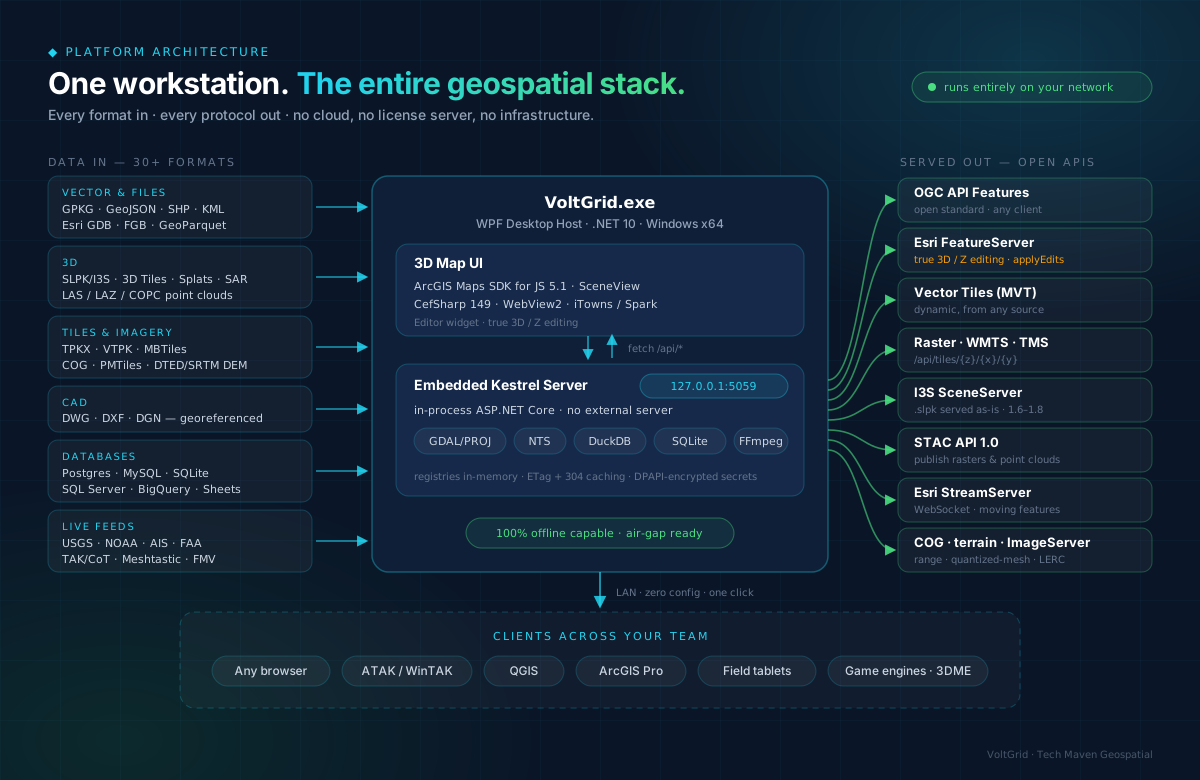
🌐 Embedded Local Server & 3D Engine
🔌 30+ Formats · 12+ Protocols
🛡️ ArcGIS & PLS-CADD Interoperability
◆ One Workstation · Every Capability
⚡ Transmission & Analytics
Network Trace + Isolation Preview
As-built vs Design QA
ROW Encroachment
Data Charts (Map Linked)
DER Hosting Capacity
OMS / SCADA Overlay
Corridor Veg & Storm Change
PLS-CADD Import
EAM / CMMS (Maximo · Cityworks)
🌐 3D Digital Twin & Formats
Offline Tile Packs (AOI→MBTiles)
CAD Modernization (DWG/DXF/DGN)
3D / Z GPKG Editing
LiDAR & Point Clouds (LAS/COPC)
IFC / BIM Import
LoD2.2 Roofer Reconstruction
I3S / SLPK · 3D Tiles · Splats
Desktop-as-a-Server
📡 Real-Time, Imagery & Enterprise
Drone FMV + AI Detection
SAM2 Imagery Segmentation
Magic Wand Digitizing
SAR / InSAR · Sentinel Feeds
12 DB Connectors · Microsoft Fabric
SharePoint Lists (Read/Write)
TAK / ATAK Crew Tracking
Offline Routing (A*) · GeoChat
◆ Built for
Utility GIS · T&D Engineering · Vegetation Mgmt · Storm & Emergency Ops · Field Ops · Substation & Asset Teams · Inspections · Utility Consultants
◆ Why Utilities Choose VoltGrid
- Ops overlays that land on the corridor. DER headroom, OMS outages, SCADA tags, Maximo/Cityworks work orders, and before/after vegetation or storm change — beside the same PLS-CADD network.
- The network model works for you. Trace feeders and preview isolations, grade as-builts against design, and sweep the ROW for encroachments — findings land in one unified queue.
- GIS, CAD, and BIM finally converge. As-built drawings, IFC models, PLS-CADD structures, and asset GIS on one map — a living, authoritative 3D digital twin of the electric grid.
- The desktop is the server. One click shares corridor and damage data LAN-wide over OGC, Esri REST, I3S, and STAC — zero cloud subscription, zero server farm tax.
- Works when the storm takes the network down. Fully air-gapped and OT capable; crews, EOCs, and staging yards keep the complete operational picture with no internet backhaul.
- Pairs with GRID State. GRID State manages the utility's assets and business operations; VoltGrid gives them living geospatial 3D twin context in the office and the field.
- Every format the utility already owns. 30+ native GIS/CAD/BIM file formats plus enterprise databases — even SharePoint inspection lists — served as open standards.
See it on your grid.
Pilot programs for qualified utilities — live demo, LAN server in minutes, ROI modeled on your territory.
support@techmaven.net